-
Task 1 (Academic): MAP
Posted by Falak on February 8, 2022 at 8:40 AMYou should spend about 20 minutes on this task.
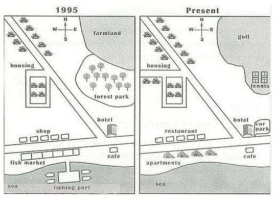
The map below shows the development of the village of Ryemouth between 1995 and present.
Summarize the information by selecting and reporting the main features and make comparisons where relevant.
Write at least 150 words.
AMANDEEP SHAH replied 2 years, 2 months ago 4 Members · 3 Replies -
3 Replies
-
The two maps illustrate the main changes which have taken in the village Ryemouth between the year 1995 and present.
Overall, village Ryemouth did not develop in size, location, but there have been significant changes in infrastructure, housing over the period given.
In 1995 village was more agrarian ,in the south side of the village there was a fishing port, fish market and shops, furthermore in the east side of the village were big territory where were located farmland and forest park and just below is the hotel and cafe.Also in north side of the village there were few houses.
At present there are increased places for people,for example in the southside are redeveloped fish markets, shops into restaurants and apartments and fishing ports are vanished at all.Also, in the north side farmland and forest park are converted into golf and tennis places,just below, as in 1995, there is a hotel and a cafe,but a car parking was built near the hotel. To all this, more houses were built on the northern side of the village.
-
The two maps depict the major changes that have occurred in the village of Ryemouth between 1995 and the present.
Overall, the core of Ryemouth has stayed constant in size and position, although the extension of its road network and housing estate has resulted in the replacement of fishing facilities, agricultural land or woods with property development and recreational amenities.. for the time period that was chosen
Apartments flanked the road heading northwest to southeast in 1995. To the northeast, there was a large tract of farmland near to a forest park. On the southern banks, there was a fishing port, and to the north, along the road running west to east, opposite a row of stores, was a fish market. A hotel and a café were separated at the southeast corner by the west-east road.
Clearly, the settlement has changed significantly over the years, as seen by the fact that the layout is completely different now. There is a golf course and a tennis court in the northeastern section, which used to be farmland and forest parks. Additionally, a new road has been constructed near the residential area, and it appears as though additional housing has been constructed. The business has been transformed into a restaurant, and the fish market into apartments. Additionally, the fishing port has been demolished and replaced with a new parking lot adjacent to the hotel. The café outside the hotel is the only thing that has remained unchanged.
-
The given maps illustrate different changes that have taken place in the village of Ryemouth since 1995.
Overall, from 1995 to present, the village has seen spectacular developments. Furthermore, the principal changes have been the addition of gold course, tennis court, restaurants and apartments.
In 1995, The village was divided in two parts by a path perpendicular to road which was running from south eastern region to south west region across the sea. the north eastern side of village have farmland and forest park. In the south eastern region, there was a hotel, alongside the road and a café, which was located to the right of the sea. In the centre of the sea, there was a fishing port. In the north west region, houses were there on the left and right of the path, and lastly in the south western corner there were shops on left side of the path and fish market which was located to left of the sea.
There have been some changes, which can be seen in the village now. Firstly, the farmland and forest park in north eastern have been replaced by golf course and tennis court, a car parking has been constructed on the right side of the hotel in south east. Secondly, the shops which were situated in south west region has been demolished and restaurants have been built there. Thirdly, fishing port which was located at centre of the sea has been removed and fish market which was located at south west corner has been replaced by restaurants. Finally, the path which has divided village into two parts has been extended towards west side of the village and more houses have been built on the left side of extended path
Log in to reply.


